?> Mapas politico de Lisboa
Lisbon District Map, Portugal

The district is composed of 16 municipalities: Alenquer, Amadora, Arruda dos Vinhos, Azambuja, Cadaval, Cascais, Lisbon, Loures, Lourinhã, Mafra, Odivelas, Oeiras, Sintra, Sobral de Monte Agraço, Torres Vedras, Vila Franca de Xira
Fuente: DGPRM/DSRM/DREM

Satellite Image, Photo of Lisbon and Tagus River Estuary, Portugal

Lisbon and Tagus River Estuary, Portugal September 1992. Lisbon, the capital of Portugal, is observable north of the Tagus River estuary in this low-oblique, northeast-looking photograph. The estuary of the Tagus River, the longest river in the Iberian Peninsula, is 12 miles (19 kilometers) long and is considered one of the best harbors in Europe. Lisbon is set on seven terraced hills and has a population of almost 900 000. Industries include textiles, chemicals, steel, oil and sugar refining, shipbuilding, soap and flour production, and tourism. A massive earthquake almost destroyed the city in 1755. Loss of life exceeded 50 000 people, and many buildings, some over 1000 years old, were destroyed. The city was rebuilt, and no subsequent major earthquakes have occurred. Visible south of the Tagus River estuary are the cites (west to east) of Almada, Barreiro, and Montijo; farther south are Setúbal Bay and the Sado River estuary.
Fuente: NASA - National Aeronautics and Space Administration

Satellite Image, Photo of Lisbon, Portugal

Lisbon, Portugal April 1998. Lisbon, the nation's capital and largest city (estimated population of 650000 people), is located along the west side and near the mouth of the Tagus River estuary (large, dark feature in center of image). The Tagus River estuary is one of the best natural ports on the European continent and can accommodate large ocean going ships. The estuary also has the largest dry dock in the world. The intersecting runways for one of Lisbon's several airports are visible on a peninsula that extends westerly into the south side of the Tagus River estuary. Two bridges can be seen connecting the eastern shore with the built-up area of Lisbon. With the exception of the alluvial soil deposited by the Tagus River and the irrigated acreage along the delta and floodplain of the river, Portugal is not a country that has an abundance of arable land. The angular-looking field patterns found on the Tagus River delta (near upper right corner) and the circular patterns (center pivot irrigation southeast of the river) show the location and distribution of some of the productive farmland. The greater Lisbon area, including both the city and its suburbs, accounts for most of Portugal's commerce and much of its industry.
Fuente: NASA - National Aeronautics and Space Administration

Satellite Image, Photo of Lisbon, Portugal

Lisbon, Portugal April 19, 1994. This radar image of Lisbon, Portugal illustrates the different land use patterns that are present in coastal Portugal. Lisbon, the national capital, lies on the north bank of the Rio Tejo where the river enters the Atlantic Ocean. The city center appears as the bright area in the center of the image. The green area west of the city center is a large city park called the Parque Florestal de Monsanto. The Lisbon Airport is visible east of the city. The Rio Tejo forms a large bay just east of the city. Many agricultural fields are visible as a patchwork pattern east of the bay. Suburban housing can be seen on the southern bank of the river. Spanning the river is the Ponte 25 de Abril, a large suspension bridge similar in architecture to San Francisco's Golden Gate Bridge. The image was acquired on April 19, 1994 and is centered at 38.8 degrees north latitude, 9.2 degrees west longitude. North is towards the upper right. The image is 50 kilometers by 30 kilometers (31 miles by 19 miles). The colors in this image represent the following radar channels and polarizations: red is L-band, horizontally transmitted and received; green is L-band, horizontally transmitted and vertically received; and blue is C-band, horizontally transmitted and vertically received. SIR-C/X-SAR, a joint mission of the German, Italian, and the United States space agencies, is part of NASA's Mission to Planet Earth.
Fuente: National Aeronautics and Space Administration - NASA JPL
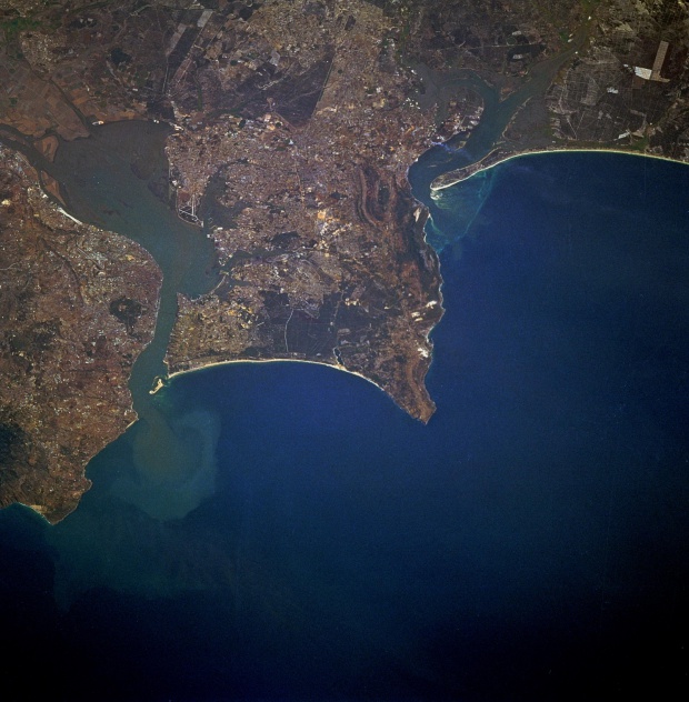
Imagen radar de Lisboa, Portugal

Esta imagen de radar de Lisboa, Portugal ilustra los diferentes patrones de uso de la tierra que están presentes en la costa de Portugal. Lisboa, la capital del país, se encuentra en su orilla más septentrional del Río Tejo donde el río entra en el Océano Atlántico. El centro de la ciudad, aparece como la zona brillante en el centro de la imagen. La zona verde al oeste del centro de la ciudad es una gran ciudad parque llamado el Parque Florestal de Monsanto. El aeropuerto de Lisboa está visible este de la ciudad. El Río Tejo forma una gran bahía al este de la ciudad. Muchos campos de cultivo son visibles como un patrón de mosaico este de la bahía. Suburban de la vivienda puede verse, en la ribera sur del río. Atravesando el río es el Ponte 25 Abril, un gran puente colgante similar en la arquitectura de San Francisco's Golden Gate Bridge. La imagen fue adquirida el 19 de abril de 1994, y está centrado en 38.8 grados de latitud norte, 9.2 grados de longitud oeste. Norte es hacia la parte superior derecha. La imagen es 50 kilómetros por 30 kilometros (31 millas por 19 millas). Los colores en esta imagen de radar representan a los siguientes canales y polarizaciones: el rojo es la banda L, horizontalmente transmitida y recibida; verde es la banda L, de transmisión horizontal y verticalmente recibido, y azul es la banda C, de transmisión horizontal y verticalmente recibido. SIR-C/X-SAR, una misión conjunta de los Gobiernos alemán, italiano, y las agencias espaciales de los Estados Unidos, es parte de NASAs Misión al Planeta Tierra.
Fuente: NASA JPL