?> Mapas politico de Estado de México
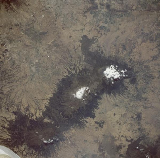
Mapa Satelital de los Volcanes Popocatépetl e Iztaccihuatl, Mexico

Tres volcanes, alineados en una dirección general Norte-Sur y situados alrededor de 72 kilómetros al Sureste de la Ciudad de México en la meseta mexicana, son claramente visibles en esta imagen. El clásico patron de drenaje de erosión asociado con muchos volcanes compuestos de ceniza explosiva y con flujos ocasionales de lava es bastante evidente alrededor de los flancos de todos estos volcanes. En una inspección cercana, numerosos conos de ceniza se pueden ver, especialmente en los llanos al oeste de los volcanes. Dos de los volcanes, Iztaccihuatl (5,285 metros) y Popocatépetl (5,452 metros) estan cubiertos de nieve en sus cumbres. Las nubes oscurecen parcialmente el gran cráter oval de Popocatépetl que mide aproximadamente 600 metros de diámetro y más de 150 metros de profundidad. El Popocatepetl situado más al Sur es el volcán más famoso de México. El significado de su nombre se deriva de una antigua palabra azteca "la montaña que fumaba." Las erupciones del volcán a mediados de los años 90 pusieron a la Ciudad de México y a comunidades circundantes en alerta. Las ultimas erupciones del Popocatépetl antes de mediados de los años 1990 ocurrieron en el siglo decimo séptimo. La forma linear al Este del volcán parece ser una pista de aterrizaje de un aeropuerto.
Fuente: National Aeronautics and Space Administration - NASA/JPL/NIMA

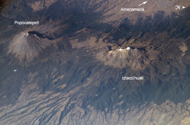
Mapa Satelital de los Volcanes Popocatépetl e Iztaccihuatl, Mexico

Popocatépetl and Iztaccíhuatl Volcanoes, Mexico. As part of the circum-Pacific "Ring of Fire," Mexico hosts several of the world's most continually active volcanoes, including the massive Popocatepetl (Aztec for "smoking mountain.") This detailed, oblique astronaut photograph also depicts a neighboring volcano, Iztaccíhuatl (the "Woman in White.") With North to the right in the scene, the view is a westward-looking perspective. The faint plume emanating from Popocatépetl's 250- to 450-meter-deep summit crater attests to the significant, ever-present hazard the volcano represents to the 25 million people living in the region, including the nearby city of Amecameca, as well as the metropolitan centers of Mexico City to the northwest and Puebla to the east. Popocatepetl has produced small, intermittent eruptions since 1994. In addition to the constant danger of eruptions producing ash deposits, pyroclastic flows, and lava (see an earlier astronaut photograph of Popocatepetl erupting), the summit of Popocatépetl also hosts glaciers. These can melt during eruptions to form dangerous mudflows that blanket areas to the south. In contrast to Popocatépetl's well-defined symmetrical cone, Iztaccíhuatl is formed from several overlapping smaller cones that trend north-northwest to south-southeast. Glaciers and year-round snow are also present on Iztaccíhuatl (white regions along the peaks). Deep valleys have been eroded into the massive apron of ash and pumice deposits, glacial outwash, and alluvium to the east of the volcano. Despite its close proximity, similar age, and similar geologic character to Popocatépetl, Iztaccíhuatl has not erupted in historic times. This has encouraged the establishment of numerous agricultural fields (visible as faint rectilinear patterns in the lower half of the image) on the eastern flank of the mountain.
Fuente: National Aeronautics and Space Administration - NASA/JPL/NIMA

Mapa del Estado de Mexico

Mapa del Estado de Mexico
Fuente: INEGI - Instituto Nacional de Estadística Geografía e Informática

Mapa de Mexico (Estado), Mexico

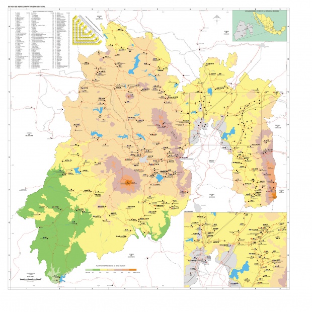
Capital Toluca, Superficie: 21,461 km², Altitud: 2,660m sobre nivel del mar, Latitud Norte: 19.17' grados, Longitud Oeste: 99.40' grados, Longitud total de kilometros de infrastructurade carretera del Estado: 9,802,12 kms, Carreteras de Cuota: 383.89 kms, Carreteras Libres: 7,069.23 kms, Caminos Rurales: 2,349.00 kms, Brechas 2,575.8 kms.
Fuente: SCT - Secretaria de Comunicaciones y Transportes